Friday 28 May 2021

Estimation of Stature from the Length of Forearm in a Population in Nedungolam Town in Kerala by Manoj Balachandran* in Open Access Journal of Biogeneric Science and Research

Estimation of Stature from the Length of Forearm in a Population in Nedungolam Town in Kerala by Manoj Balachandran* in Open Access Journal of Biogeneric Science and Research


Abstract

Today, one of the most important issues is that to understand how the severity of heavy precipitation and floods can change in future time in comparison with the current period. The aim of this research is to realize the effect of future climate change on storm water and probability of maximum flood for future time period. Zayandeh rud river basin in Iran is selected as a case study. Prediction of future climatic parameters based on temperature and precipitation of the upcoming period (2006-2040) is done with using the HadCM3 model and based on RCP 2.6, 4.5, and 8.5 emission patterns. Also, climate change model is downscaled statistically with using LARS-WG. In the next step, the probable of maximum precipitation is assessed through synoptic method and then, in order to model maximum storm water under the climate change effects, the HEC-HMS for simulating rainfall-runoff model is used. Also, the Snowmelt Runoff Model (SRM) is used to simulate snow melting.  The results of this research show the maximum of probable precipitation in the basin for the period of 2006-2040 under the scenario RCP 2.6, can increase by 5% and by the scenarios of RCP 4.5 and RCP 8.5 can decrease by 5% and 10%, respectively in comparison with the current period 1970-2005.

Keywords: Climate change, effects, maximum rainfall, storm water, climate scenarios.

Introduction

Identification of the individual is one of the most important aspects of forensic investigation. Stature is an important data in identification. When only some part of the body is available, stature estimation becomes difficult. The factors which play an important role in human development and growth are racial, ethnic and nutritional factors. Nedungolam is the Northern border town of Paravur municipality in the Kollam district of Kerala state, India. Estimation of stature from the length of forearm has not been done in the present area of study so far and hence this study is quite useful.

Previous accessible records can be used for comparison for the identification of human beings. Prediction of stature from long bones holds a central position in Forensic Anthropology. There are two methods used for stature reconstruction i.e., anatomical and mathematical methods. Anatomical method requires the complete skeleton whereas mathematical method can be done even with a single bone. In the present study, an attempt has been made to formulate multiplication factors and regression equations for stature estimation among subjects belonging to Nedungolam town of Kollam district in Kerala.1 Osteological or dental examination can be used for identification. To identify a person assessment of age and sex are used in forensic examinations.

Stature, age, sex, and ancestry will help to identify a person among victims in forensic investigations. The different body parts have a relationship which can help a forensic scientist to calculate stature from mutilated and dismembered body parts in forensic examinations. This helps in events of murders, accidents or natural disasters. Stature can even be estimated from feet or foot prints, imprints of the hand or from a shoe left at the scene of a crime.

In putrefied, mutilated and extensively charred bodies, conventional indicators and routine methods of identification may not yield the desired results. Mutilated and fragmentary remains are only available due to mass disasters in some cases. The relationship of every body part with stature is more or less constant. Many studies have found a positive correlation between stature and hand dimensions. The relationship between a particular body part and stature will be different for the same race belonging to different areas. The formula for stature estimation has to be population specific.

Review of Literature

Stature is one of the important parameters which contributes to the identification of a person even after death.1 The study titled “Estimation of stature from forearm ength in North Indians- An Anthropometric study” by Bikramjeet Singh et al. (2013) has made an attempt to formulate multiplication factors and regression equations for stature estimation among subjects belonging to different areas of North India. The study was carried out on 400 subjects (200 males and 200 females). It was found that males exhibit greater dimensions than females for forearm length and stature. Males exhibit greater mean multiplication factor for forearm length than females from North India. There is a positive correlation between stature and upper arm length. The regression equations and multiplication factors derived in the study are quite handy for use by lay public like police [1].

The study done by Song-in et al., stresses the importance of estimation of stature from incomplete human remains for the purpose of identification. The estimated stature may be used to narrow down the search among missing person’s list. The present study gives appropriate regression equations to estimate stature from percutaneous forearm length for Thai children aged between 5 and 19 years. The subjects did not have any physical deformities. Stature was measured using a stadiometer and forearm length using a digital caliper. The results in the present study showed high correlation between stature and forearm length in both sexes. The results obtained in this study can be used for the estimation of stature from forearm length in Thai children [2].

The background of the study “Estimation of stature from the study of ulna in Maharashtrian population” by Bamne et al. (2015) emphasises that stature has an important place in the field of Forensic Medicine and Anthropometry. The study made an attempt to estimate linear regression equation from the length of ulna. There were 200 study subjects (100 men and 100 women) of Maharashtrian population with age ranging from 20 to 25 years who were in the Department of Anatomy, Krishna Institutes of Medical Sciences University, Karad, Maharashtra, India. The study revealed a positive correlation between total height of individuals and length of ulna which was 0.73 for men and 0.70 for women. The study proved quite reliable in the estimation of stature from the length of ulna in forensic examinations [3].

The study by Poorhassan M et al. (2017) evaluates the relation between forearm length and height. The study population included 100 male and 100 female Iranian medical students. Relation between forearm length and stature were estimated using linear regression analysis. The mean age of subjects was 22 +/- 2.21 years. The study found a correlation between height and forearm length of all subjects. Linear regression also showed a relation between height and upper arm length of subjects. Thus it proved that forearm length was a moderate predictor of stature of medical students in Iranian population [4].

This study “Estimation of stature from anthropometry of hand: an interesting autopsy-based study in Madhya Pradesh, India” by Goswami et al. (2016). Height is the central aspect of anthropo-forensic examination. The human hand is mainly used for these investigations. Hand length can also be used to calculate ideal body weight and body surface area in either sex. This study was conducted in the mortuary of Department of Forensic Medicine, Mahatma Gandhi Memorial Medical College and M.Y. Hospital, Indore (M.P.), India from September 2014 to September 2015. The study was conducted on 250 male and 250 female deceased individuals. The average age of males was 38 and that of females taken for the study was 34 years. Mean hand length in males was greater on the right side and in females on the left side. Hand breadth was more on right side in males and on the left side in females. Mean height in males was 163 cm and 155 cm in females [5].

The study “Estimation of stature from the hand and foot measurements in a rare tribe of Kerala State in India” by Geetha et al. (2015) was undertaken on the Vettuvar group of tribes of Kasargode district of Kerala State, India and explores the usability of the dimensions of hands and feet as predictors of stature. This study is the first ever documented study on the tribes of Kasargode district, Kerala. The study subjects were 100 males and 100 females in the age group 20-30 years. A sliding caliper was used for the measurements of hand and feet dimensions. Stature was measured using Stadiometer [6].

An attempt to calculate the stature length from ulna length among Kurdish racial subgroup living in Iran was done in the study “Stature estimation and formulation of based on ulna length in Kurdish racial subgroup” by Ghanbari et al. (2016). 50 females in the age group 19-24 years were selected for the study. A digital sliding caliper was used for taking ulna length. Vertex to floor length was taken as height. Height was also calculated using linear regression formula. The derived formula was population specific to the Kurdish racial subgroup. This study also threw light on the range of ulna length in girls of Kurdish ethnic subgroup. It can be used for further investigations on ethnic subgroups living in Iran [7].

The study “Estimation of the height of an individual to the forearm length” by Sandhya et al. (2016) compared the height of the individual to the forearm length. The estimation of stature from the skeleton bears immense importance in forensic sciences. After analysis of the parameters a positive correlation between height of individuals and forearm length was found. The regression formula used in this study is of immense help to forensic sciences, anatomist and clinicians. Future studies can focus on estimating the stature from different body parameters based on this study [8].

Estimation of Stature from the Measurement of Forearm, Hand, Leg, and Foot Dimensions in Uttar Pradesh Region done by Yadav et al. (2018). Measurement of human body and its different parts are used in the detection and correction of body defects, preparation for cosmetic surgeries and estimation of general health. It can also be used to identify criminals. This study was done to find out a correlation between the length of forearm, hand, leg and foot with stature. The study was conducted on students aged between 17 & 21 years of both genders. Sample size was 200, 100 males and 100 females. Standard height measuring machine and tape were used. Of the parameters used leg length showed the highest correlation and foot length showed the least correlation with stature. This study data is helpful in medicolegal cases, among people of different regions when only some parts of the body are available [9].

The study titled “A model for individual height estimation from forearm length in natives of Kerman, Iran” done by Vaghefi et al. (2014) was done to find out the correlation between forearm length and height in natives of Kerman. It was a cross sectional study of 150 cases with 75 males and 75 females (aged 18 to 22 years) of Kermanian population. Height and left forearm length were measured in standard positions. Linear regression analysis was used in this study. There was a significant difference in the height of cases between two sex groups. There was significant difference in the forearm length of sex groups. A correlation between height and forearm length of male and female cases were also noticed. Forearm length was found to be a suitable factor for height estimation. It was a moderate predictor of height in native males and females of Kerman [10].

Research Question

Is there a correlation between the length of forearm and the height of an individual?

Objectives

The objectives of this study are

  1. To determine sexual dimorphism in estimating stature from the length of forearm.
  2. To derive a formula for the estimation of stature from the length of forearm.

Study Design & Methodology

The study subjects were 200 healthy adult males and females of Nedungolam town in Kollam district, Kerala. The present study was aimed at measuring the stature from the length of forearm.

  • Method of Collection of Data: Informed written consent was obtained from the subjects.
  • Measurement of Stature Using Stadiometer: It was measured as vertical distance from the vertex to the foot. Measurement was taken by making the subject to stand erect on a horizontal resting plane, on the stadiometer bare footed. Palms of hand turned inwards and fingers horizontally pointing downwards and head oriented in eye-ear-eye plane (Frankfurt Plane). The movable rod of the stadiometer was brought in contact with vertex in the mid sagittal plane (Figure 1).
  • Measurement of Forearm Length with Measuring Tape: The forearm length will be measured using a standard plastic measuring tape and will e taken as the distance between the midline of the crease of the elbow and the midline of the most distal crease of the wrist, just below the hand (Figure 2).
  • Sample Size: Considering the correlation between the height of the individual and length of forearm minimum sample size required was
  • Statistical Analysis: For the first objective of sexual dimorphism in estimating stature from the length of right index finger logistic regression can be used. For the second objective of estimating stature from the length of right index finger simple linear regression can be used for males and females.
  • Source of Data: Patients who visited various OPD departments of Taluk Hospital, Nedungolam, Kollam district, Kerala.
  • Inclusion Criteria: Subjects aged between 18-60 years of Indian origin.
  • Exclusion Criteria: Subjects having significant diseases, congenitally malformed limbs, metabolic disorders and developmental defects.

    Observation and Results: (Tables 1-10)

Table 1: Sex (Male/ Female).
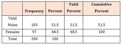
Table 2: Descriptive Statistics.

Table 3: Symmetric Measures.

Table 4: Symmetric Measures.

Table 5: Coefficientsa

Table 6: Coefficientsa

Table 7: Coefficientsa

Table 8: Coefficientsa

Table 9: Coefficientsa

Table 10: Coefficientsa

Table 11: Comparison of the results of various studies.
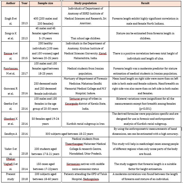
Figure 1: Measurement of height in Frankfurt plane.

Figure 2:  Measurement of the length of forearm using Measuring tape.

Discussion

The present study was done on patients who visited the OPD of Taluk Hospital, Nedungolam, who were aged between 18-60 years and were of Indian origin. The forearm length was measured using a Measuring tape and the stature of the individual by a stadiometer. The exact age of the person and the area of residence were identified from his/her government issued identity card. The study showed a significant correlation between the length of forearm and the stature of the individual. The table given below shows a comparison between different studies that were used as reference and the present study (Table 11).

In the study titled “Estimation of stature from forearm length in North Indians- An Anthropometric study” it was found that male North Indians exhibit greater dimensions than the females for the forearm length and the stature. Stature was measured using an anthropometric board and forearm length using a measuring tape. Also greater mean Multiplication factor for forearm length were found in males than in females. Stature and upper arm length also showed positive and significant correlation.1 This study is different from our study where forearm length is used to find out stature of an individual.

In the study by Song-in K et al., stature and forearm lengths were measured from a total of 90 (45 males and 45 females) children in the central region of Thailand. The results show that the mean stature and all forearm lengths of males are higher than those of females; similar findings were observed in previous studies. Stature and forearm length were measured using a stadiometer and a digital caliper. The results obtained proved that forearm length can be efficiently used for stature estimation.2 This study is similar to our present study in that forearm length is used to calculate the stature of an individual.

Bamne A et al. studied the relationship between ulnar length and the stature of an individual. This study showed higher mean values in each anthropometric measurement than among women. Standard Vernier Caliper was used for measuring ulnar length. Standard flexible steel tape was used for measuring total height of an individual. It was found that the stature of a person can be estimated with great accuracy using the length of the ulna. The regression equations can be used in artificial limb centres for construction of prosthesis required in cases of amputations. It can be helpful in biometrics and can also be used for anthropological studies.3 This study has employed only the measurement of one of the bones of the forearm i.e., the ulna whereas in our present study the entire length of forearm is used to estimate stature.

Poorhassan M et al. in their study found that there was a relation between height and upper arm length of subjects in all cases. There was also a relation between stature and forearm length in male subjects. Stadiometer was used for stature measurement and standard tape for forearm length measurement. But this was not found in case of female subjects. Mean stature was higher for males than females. Forearm length was found to be a moderate predictor for stature estimation in medical students in Iranian population.4 This study is quite similar to our present study in that forearm length is used to calculate stature.

Goswami et al.’s study can be used as baseline information for other population-based studies in the study area. Standard Vernier caliper, standard measuring tape and standard measuring scale were used for the study. This information can be used by anthropologists, forensic and other medicolegal experts to estimate the stature by the use of length and width of hand within the standard error of estimate. The differences in different populations should be used to apply such formula to other populations.5 This study is different from our present study in that hand length and hand breadth were used for stature estimation.

The findings in the study by Geetha G et al. may be used to predict stature in cases where whole length of hand and foot were not available for investigation. The data obtained can be used for getting certain population specific anthropometric indices amongst the tribal population. Sliding caliper was used for hand and feet measurements and Stadiometer was used to measure vertical height for stature estimation. This is the first ever documented anthropological work among the tribal population of Kasargode.6 In this study stature was estimated using multiple parameters while our present study used only a single parameter for stature estimation.

Ghanbari K et al. showed the range of ulna length in girls of Kurdish ethnic subgroup and the data obtained in this study was used to estimate stature in Kurdish ethnic subgroup on the basis of ulna length. Digital sliding caliper was used to measure ulna length and height was taken when person was standing in anatomical position and head in the Frankfurt plane. It can also be used for further investigations on ethnic subgroups living in Iran.7 In this study also a single forearm bone length was used for stature estimation like the study done by Bamne et al. in 2015.

Sandhya A proved in her study that from the length of forearm the height of an individual can be estimated. Height was measured against a wall using a ruler, pencil and measuring tape. Forearm length was measured using a standard measuring tape. This study also paved way for future studies to focus on estimating height using other different body parameters.8 This study also uses forearm length to determine stature like our present study.

The study by Yadav S et al. showed that second highest degree of correlation was found for forearm length with regression coefficient. A standard height measuring instrument was used for estimating stature and various other parameters of right and left sides were measured using measuring tape. The regression coefficient in this study showed stature and dimension of hand was the third most correlated value.9 This study uses multiple parameters like forearm length, hand length, leg length and foot length for stature estimation while our present study uses only a single parameter.

Eftikar Vaghefi S et al. in their study showed that forearm length was a valuable predictor for height estimation. Stadiometer and standard measuring tape were used for stature measurement and forearm length measurement respectively. This factor was also a moderate predictor of height in native males and females of Kerman.10 This study is quite similar to our present study with respect to the parameters used and the methodology employed. The findings in the present study done on subjects in Nedungolam town in Kerala showed that there is a moderate correlation between the length of forearm and stature of an individual.

Conclusion and Summary

A moderate correlation was found between right forearm length and Height and this correlation is highly statistically significant. There is also a moderate correlation between Left forearm length and Height and this correlation is also highly statistically significant. The following formulae were derived for the estimation of stature in the study.

  1. HEIGHT (MALE) = 90.24+2.19*Right forearm length
  2. HEIGHT (MALE) = 88.65+2.98 × Left forearm length
  3. HEIGHT (FEMALE) = 77.32+3.19*Right forearm length
  4. HEIGHT (FEMALE) = 79.18+3.12 × Left forearm length
  5. HEIGHT = 58.54+4.06*Right forearm length
  6. HEIGHT = 59.63+ 4.03× Left forearm length

The first four formulae exhibit the sexual dimorphism in estimating stature from the length of forearm in both the sexes. The last two formulae were common for both genders.

Recommendations

Various other parameters can be used for stature estimation like the arm length, hand length, foot length and head circumference. The study can be extended to people belonging to different races and the values compared.

More information regarding this Article visit: OAJBGSR

Tuesday 25 May 2021

Structural Diagram of Actuator for Nanobiotechnology

Structural Diagram of Actuator for Nanobiotechnology by Afonin SM* in Open Access Journal of Biogeneric Science and Research


Abstract

The structural diagram of an electro magnetoelastic actuator for nanobiotechnology is obtained. The structural diagram of an electro magnetoelastic actuator has a difference in the visibility of energy conversion from the circuit of a piezo vibrator. The electro magnetoelasticity equation and the differential equation are solved to construct the structural diagram and model of the actuator. The structural diagram of the piezo actuator is obtained by using the reverse and direct piezoelectric effects. The structural model of the piezo actuator for control systems in nanobiotechnology is written. The transfer functions of the electro magnetoelastic actuator are obtained.

Keywords: Structural diagram and model; Actuator; Nanobiotechnology; Electro magnetoelastic actuator; Piezo
actuator; Deformation; Transfer function

Introduction

Electro magnetoelastic actuators in the form of piezo actuators or magnetostriction actuators are used in nanomanipulators, laser systems, nano pumps, scanning and nanomanipulation in nanobiotechnology [1-6]. The piezo actuator is used for nano displacements in photolithography, in medical equipment for precise instrument delivery during microsurgical operations, in optical-mechanical devices, in adaptive optics systems, and in adaptive telescopes. It is also used in stabilization systems for optical-mechanical devices, systems for alignment and tuning of lasers, interferometers, adaptive optical systems and fiber-optic systems for transmitting and receiving information [4-12].

The electromagnetoelasticity equation and the differential equation are solved to obtain the structural model of the actuator. The structural diagram of the actuator has a difference in the visibility of energy conversion for from Cady and Mason electrical equivalent circuits of a piezo vibrator. The structural diagram of the actuator for nanobiotechnology is obtained by applying the theory of electro magnetoelasticity [4-8].

Structural Diagram

The structural diagram of an electro magnetoelastic actuator for nanobiotechnology is changed from Cady and Mason electrical equivalent circuits [4-8]. The equation of electro magnetoelasticity [2-14] has the form of the equation of the reverse effect for the actuator

The equation of the force on the face of actuator has the form [10-15]

The differential equation of the actuator has the form [4-29]

coefficient of wave propagation, the speed of sound, the coefficient of attenuation

The decision of the differential equation of the actuator has the form

where  C, B are the coefficients

The coefficients C , B have the form

The system of the equations stresses acting on its faces has the form

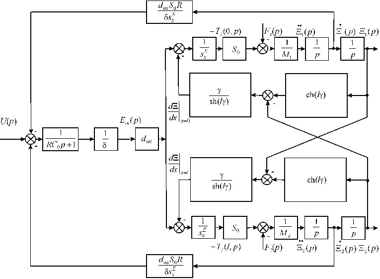
Figure 1: Structural diagram of actuator for nanobiotechnology.

The system of equations for the structural diagram on (Figure 1) and model of an actuator for nanobiotechnology has the form

electric field, H is the intensity of magnetic field.

After conversion the system of the equations for the structural model has form

After conversion the system of the equations has the form

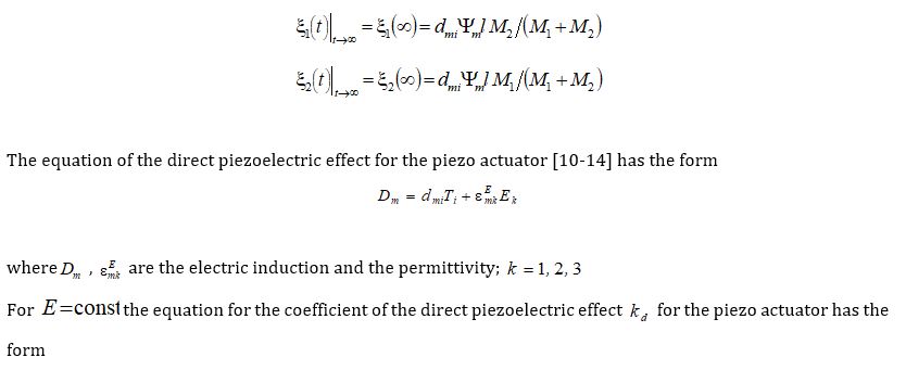
Therefore, for the inertial load the steady-state displacements and of the actuator for nanobiotechnology have the form

Figure 2: Structural diagram of piezo actuator for nanobiotechnology.

After conversion (Figure 1) the structural diagram of the piezo actuator for nanobiotechnology has form (Figure 2)

The equation for the coefficient of the reverse piezoelectric effect  is found in the form

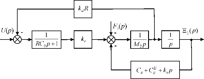
Figure 3: Structural diagram of piezo actuator at elastic-inertial load.

The structural diagram of the piezo actuator for the lumped parameters is obtained on (Figure 3).

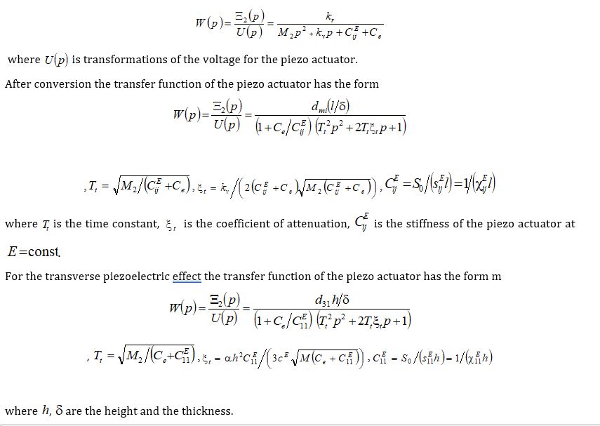
The transfer function of the piezo actuator for the lumped parameters on (Figure 3) at R=0  has the form

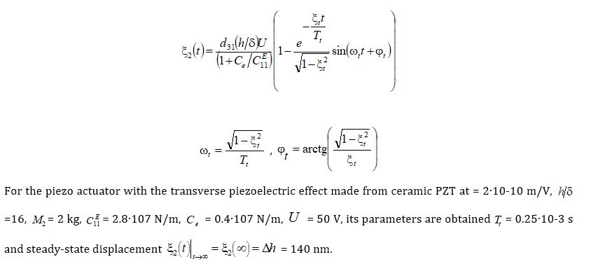
For the step input voltage the transient process of the piezo actuator at the transverse piezoelectric effect has the form

Characteristics

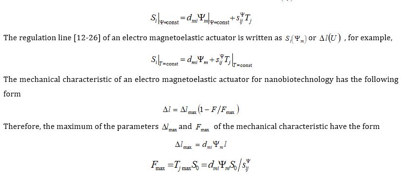
The characteristics of an electro magnetoelastic actuator for nanobiotechnology are obtained. The mechanical characteristic [10-38] of the actuator for nanobiotechnology is obtained as Si(Tj) or  ^l(F)  or , for example,

where index max is used for the maximum value of parameter.

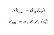
For the transverse piezoelectric effect the maximum values of parameters of the piezo actuator for nanobiotechnology have the form

Figure 4: Mechanical characteristic of transverse piezo actuator.

For the transverse piezo actuator for nanobiotechnology at d31= 2∙10-10 m/V,  E3= 1∙105 V/m,  h= 2.5∙10-2 m, S0= 1.5∙10-5 m2, Se11= 15∙10-12 m2/N its parameters on (Figure 4) are found  hmax= 500 nm and Fmax = 20 N.

At elastic load the regulation line of an electro magnetoelastic actuator for nanobiotechnology is obtained in the form

Therefore, the equation of the displacement at elastic load has the form

For the transverse piezoelectric effect of the piezo actuator for nanobiotechnology the equation of the displacement at elastic load has the form

Theoretical and practical parameters are coincidences with an error of 10%.

For calculations the mechatronics control systems in nanobiotechnology with an electro magnetoelastic actuator its characteristics are found.

Conclusion

The structural diagram of an electro magnetoelastic actuator for nanobiotechnology is obtained. The structural diagram of an electro magnetoelastic actuator has a difference in the visibility of energy conversion from the circuit of a piezo vibrator. The structural diagram of an electro magnetoelastic actuator for nanotechnology is changed from Cady and Mason electrical equivalent circuits of a piezo vibrator.

The structural diagram of an electro magnetoelastic actuator is found from its electro magnetoelasticity and differential equations. The structural diagram of the piezo actuator is obtained using the reverse and direct piezoelectric effects. The back electromotive force for the piezo actuator is written from the direct piezoelectric effect. The characteristics of an electro magnetoelastic actuator for nanobiotechnology are obtained. The regulation line of the piezo actuator is found.

More information regarding this Article visit: OAJBGSR

Wednesday 19 May 2021

Modeling the Effects of Climate Change on Probability of Maximum Rainfall and on Variations in Storm Water in the Zayandeh Rud River

Modeling the Effects of Climate Change on Probability of Maximum Rainfall and on Variations in Storm Water in the Zayandeh Rud River by Safieh Javadinejad* in Open Access Journal of Biogeneric Science and Research


Abstract

Today, one of the most important issues is that to understand how the severity of heavy precipitation and floods can change in future time in comparison with the current period. The aim of this research is to realize the effect of future climate change on storm water and probability of maximum flood for future time period. Zayandeh rud river basin in Iran is selected as a case study. Prediction of future climatic parameters based on temperature and precipitation of the upcoming period (2006-2040) is done with using the HadCM3 model and based on RCP 2.6, 4.5, and 8.5 emission patterns. Also, climate change model is downscaled statistically with using LARS-WG. In the next step, the probable of maximum precipitation is assessed through synoptic method and then, in order to model maximum storm water under the climate change effects, the HEC-HMS for simulating rainfall-runoff model is used. Also, the Snowmelt Runoff Model (SRM) is used to simulate snow melting.  The results of this research show the maximum of probable precipitation in the basin for the period of 2006-2040 under the scenario RCP 2.6, can increase by 5% and by the scenarios of RCP 4.5 and RCP 8.5 can decrease by 5% and 10%, respectively in comparison with the current period 1970-2005.

Keywords: Climate change, effects, maximum rainfall, storm water, climate scenarios.

Introduction

The warming of the earth and its effect on the water cycle is an issue that today all the scientists of the field of science have agreed with the effect. The IPCC reported (with 99% confidence) that the surface temperature will increase between 0.4-0.78 ˚C from the 19th century [1]. Also, in the world scale since the year of 1990, we have been 10 years of severe drought [2,3]. According to the IPCC, observed heating, over the last few decades, has led to a change in the hydrological cycle and in large scale, cause increasing evaporation, changing rainfall patterns, increasing severe events, reducing snow area and increasing melting levels, changes in soil moisture and runoff [4]. So the probability of encountering major climatic events such as flooding have increased [5,6]. Since increasing this probability for the future period can have harmful effects on human societies, in recent years, researches on this topic have done for the various catchment areas at the surface of the planet [7-9]. All the researches showed that the effects of climate change on storm water and flood damage may be significant, but this depends on the climate scenarios used [10-12]. There are some reasons that show global warming can lead to an increase in PMP [13].

First, the “Clausius-Clapeyron” relationship shows that the water Saturation vapor pressure increases with temperature, so the production system can produce more rainfall [14]. Secondly, heating can cause an increase in the length of the convection season, especially when the maximum precipitation events occurred [1516]. Another issue is that rising runoff in the rainy season can increase the risk of storm water and flooding [17]. Therefore, maximum flood risk in rivers (PMF) is one of the important criteria for designing hydraulic structures which according to this phenomenon can change [18]. Thober et al. [19] reviewed the flood changes of the present century in Europe and analyzed the peak discharge values using appropriate statistical distributions. The results of this study showed that flood values doubled with return period of more than 400 years over the course of three decades in Europe [20]. Arnell and Gosling [10] investigate the magnitude of the large changes, and the return period of peak flood on a global scale using the HadCM3 model and scenario A1B. According to their results, in 10% of the regions, floods with a return period of 400 years in 2050 at least two times can happen, and flood risk changes will range from -9% to 378%. Arnell et al. [11] on a research showed that by doubling CO2, the frequency of heavy rainfall increased and the frequency of low rainfall events decreased.

It also showed that the return period for heavy rainfall in Australia declined [21]. Pudmenzky [22] showed the changes in the potential damage caused by flood events due to the increase of CO2 concentration in the three river basins Hawkesbury-Nepean and Quean Beyan and Upper Parramatta in South Australia. In the research, most of the scenarios for GCM models predict little variation in urban flood damage, while with a CO2 doubling scenario, more damage was estimated. Dadson et al. [23] contributors (1000) examined the effects of a change in urban flood events in watersheds in Wales and the United Kingdom. In this research, the HADCM2 model and the UKCIP98 variation scenario have been used, while the use of this scenario shows a small change in the frequency of heavy floods, but the flood returns vary [24]. Sadeghi et al. [25] in a study showed that rainfall intensity for future time period in the Bakhtiari basin will higher than intensity rainfall for historical time period, which indicates an increase in flood events in the upcoming period. Hemmati and Maleki, [26], with a study of the effect of changes in the flow rate (minimum and maximum flood flow) in the Sefid Rud basin, showed that the total annual precipitation and the maximum precipitation of 11 hours were significant in a small number of stations, while minimum and maximum flood events, this ratio is higher [27]. Arheimer and Lindström, [28] investigated the effect of climate change on variation in flood regime in a basin (on intensity and frequency). The results of probabilistic distribution fitting to the maximum annual flood series and comparing the severity of floods with different return periods with observed data indicate that the impact of climate change can alter the flood regime of the basin in the coming periods.

Considering the importance of the Zayandeh Rud Basin as one of the most important watersheds in Iran for the discharge and the existence of hydraulic structures, the construction that plan to build in this basin, so it is important to understand how climate change affects the storm flow and probability of maximum flood and following that how climate change can effect on dimensions of the structures and the necessary planning during storm water and flood events [29]. Therefore, the purpose of this study is to investigate the effect of climate change on the maximum precipitation and maximum flood potential of this river in Ghale- Shahrokh station. For this purpose, maximum potential precipitation (PMP) and maximum potential flood (PMF) were then first determined, and then the effect of the change in the maximum and maximum flood events was studied.

Materials and Methods

Study Area

The study basin is one of the main basin districts of the desert, with an area of 41548 square kilometers, between 32 ̊ 10΄   to ́ 33 ̊ 40΄ northern latitude and 50 ° 30΄ to 53 ° 23΄ eastern longitude. The geographical area is limited from the north of Salt Lake to the west of the Gulf of Oman and the Oman Sea, and from the east of the Kavir-siyahkooh mountain rangeto the south of the Kavirirsirjan subzone. Among its important rivers, Zayandeh Rood has a length of 405 K, Khoshkehrood River has a length of 165 km, Izodkhad has a length of 125 km, Segonbad has a length of 85 km, Kahrooye has a length of 60 km long, Dharar has a length of 52 km, Esfarian has a length 50 km, Tighezard has a length of 50 km, and Joshaghan has a length of 40 km. The catchment area covers parts of the provinces of Isfahan, Chaharmahal and Bakhtiari, Fars and Yazd, with Isfahan Province having more than 83% and Yazd having less than 3.5%, the largest and the lowest shares, respectively. (Figure 1) shows the study area.

Figure 1The area studied in the Zayandeh Rood Basin ( Javadinejad S. 2016).

Natural flows of the Zayandehrood River increase with the diversion of water from the deviant tunnels of the first and second Koohrang, which originates from Koohrang River in Chaharmahal and Bakhtiari province. Because the average rainfall in the basin is less than 150 mm per year. Zayandeh Rud Dam storage in Chadegan is provided by spring and winter runoff and released as a stream set in the river. The upstream parts of the basin cover less than 10% of the entire basin, which is mostly mountainous. The central and lower parts of the basin consist of sedimentary plains, with the most consuming agriculture (89%). Also, a large number of overflows and detours have been constructed along the river, thus water is drained for urban and industrial areas. Zayandehrud basin ends in natural swamp and gullous salts.

In this research, the meteorological data for determining the future climate of this area and the statistics of hydrometric stations data are used to simulate the runoff used in station selection. Criteria such as the existence of long statistics of low statistical errors are considered.

Methods

To do this research, at first, maximum probable rainfall (PMP) was estimated by synoptic method for different continuations. Then, using the HEC-HMS rainfall model and snow melting SRM, the maximum probable flood (PMF) was estimated. In the next step, the parameters of temperature and precipitation parameters of the general circulation model of HadCM3 atmosphere were quantified using the LARS-WG statistical method and the change factor method. By introducing the values of precipitation and temperature (which are downscaled) and applied to the hydrological models used, the impact of variations of precipitation and temperature (as climatic parameters) on the storm water and maximum flood probability was estimated.

Data

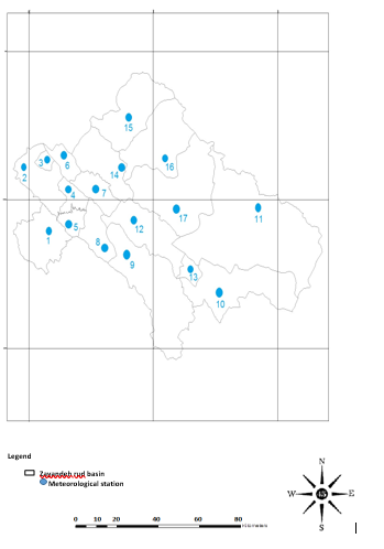
The data required in this study is data on several rain gauge and hydrometric stations and weather data such as minimum temperature, maximum temperature, precipitation, sunny day, wind speed, dew point temperature, and pressure. This information was obtained from the Meteorological Organization and the Ministry of Energy. The (Figure 1 & 2) show the position of the rain gauge stations and hydrometers used on the map of the area.

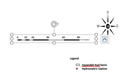
Figure 2Location of hydrometry station.

Estimated Maximum Probable Precipitation

After accurately checking the daily rainfall statistics of basin stations and comparing them with discharge of hydrometric station, seven storms which had maximum rainfall and maximum discharge, were identified and extracted. Then, for the spatial distribution of storm rainfall using Kriging statistical ground method and semi-exponential variogram model, the storm levels were plotted in GIS environment for different continuity and estimated by means of DAD measure method for rainfall storms. In the next step, after the extraction of the maximum 12-hour dew point in 40-day periods in a long period of time, the frequency analysis was used for this data. Then using the normal log distribution as the most suitable distribution for this quantity, the dew point temperature for the different return periods was extracted using the Hyfa software and based on the recommendations of the World Meteorological Organization, the temperature of the 12-hour steady dew point with a 50-year return period was used to calculate the coefficient Maximization selected. Then, in order to optimize the moisture content, using the Skew-T-Log-P diagram, the maximum temperature of the storm dew point and the maximum dew point temperature with a period of 50 years return to 4000 HPA, and according to the proposed World Meteorological Organization's tables, the precipitable water for each storm Selected and for the studied stations were calculated. To calculate the moisture maximization coefficient, the general relationship of precipitation water content for maximum dew point temperature with continuous 41-hour persistence with a 50-year return period over a ten-day period has been used to provide precipitated water for maximum dew point temperatures with a 41-hour continuation in the storm days. The maximum coefficient of the storm is calculated with respect to climatic elements that maximize the flow of moisture into the storm and maximize rainfall. In fact, the storm maximization coefficient is the maximum potential for precipitation, which is obtained from the following equation.

FM=MP×MW                                                                                      Equation (1)

Where, FM is the storm maximization coefficient with a maximum input moisture content, MP is the maximum precipitation factor depending on the temperature of the 41-hour dew point and MW is the maximum wind speed of 41 stable hours.

In the current study, the equal humidity in the source of moisture and the area under study and the high simultaneous effect of both factors of maximization, the wind coefficient in calculations of maximum probable rainfall has not been applied. In fact, with the application of the wind factor in a proportional manner, the maximum probable precipitation is estimated to be much higher than that of the real bearer. Therefore, in the above equation, MW = 1 is assumed, and the final maximization factor is equal to the moisture maximization factor.

Rainfall Distribution Pattern

In the process of converting maximum probable rainfall to maximum flood, determining the pattern of rainfall distribution in stations and in the area under study is essential. To do this, firstly, multi-storm rainfall data with different time constants were plotted as non-dimensional. To make the non-dimensional, the data of each storm, the cumulative depth of precipitation was divided up into the total depth of the storm. The same method was used for the time axis. Analyzing the stability data of rainfall stations in the basin, it was found that at most stations 40% of precipitation in the first quarter, 90% of precipitation in the second quarter, 10 % of rainfall in the third quarter and 10% of precipitation occurred in the fourth quarter time.

Creating a Climate Scenario for the Future

Most climate predictions are based on the simulation of general atmospheric cycle models. GCM Models in the spatial scale usually brings the atmosphere to 5 to 10 unequal layers, and the layers close to the Earth's surface are less spaced. In this research, the output of the HadCM3 model from the climate research and forecasting center Hadley in England is used. Because this model has the best similarity with observed data in CDF curve and among 39 models the model of HadCM3 is used, because it shows better climate signal when compare simulated and observed model of historical period.

Emission Scenarios

The IPCC has so far presented different scenarios, the RCP (Representative Concentration Pathways),is the most recent one. In this research, three RCP 2.6, RCP 4.5 and RCP 8.5 emission scenarios were used to study temperature and precipitation changes. The different scenarios show the smooth, mild and severe conditions of climate change.

Creating a Changeable Scenario

In order to eliminate disturbances in the simulation of climate fluctuations due to the large size of the computational cells of the models AOGCM, as a rule, "instead of directly using model data in climate change calculations, the yearly average of this data is used. Therefore, in order to calculate the climate change scenario in each model, the "difference" values for the temperature from equation 2 and "ratio" for the rain, from equation 3 for the long-term average of each month for future time period (2006-2040) and the simulated period (1971-2005) base by the same model calculated for each cell of the computing grid.

∆T= (T ̅GCM fut  - T ̅GCM base)                                                                    Equation (2)

∆P= (P ̅   GCM FUT)/(P ̅   GCM base)                                                                                     Equation (3)

In equation 2, T ̅GCM fut  is the 34 year average temperature simulated by AOGCM for future time period. T ̅GCM base is the 34 year average temperature simulated by the AOGCM - in the same period as the observed time period. Equation 2 is for the precipitation.

Spatial Downscaling

One of the major problems in using the output of AOGCM models is the large scale of their computing cells in terms of the spatial changes of study area in the region. In this study, to downscale the data are based on the LARS-WG statistical model. The LARS-WG model is an artificial data source for weather data that can be used to simulate meteorological data in a single location of current and future climate conditions.

The statistical properties of the generated data (modeled data) are similar to the statistical properties of historical period (observed data) but the standard deviations of GCM model are different from observed data. Data is generated in daily time series for a series of suitable climate variables such as rainfall, minimum and maximum temperature, and radiation. After assuring the accuracy of the results of the model's assessment and its ability to simulate the meteorological data, this model was used for quantifying the data of the HadCM3 atmospheric general circulation model and producing or simulating the climatic data of 2006-2040 using RCP 2.6, RCP 4.5 and RCP 8.5 scenarios and the daily values of climate parameters were generated.

Temporal Downscaling

In this research, the change factor method is used to minimize the scale of the project data. In this method, relations 4 and 5 are used to obtain the time series of the future climate scenario.

T= T obs +∆T                                                                       Equation (4)

P= P obs * ∆P                                                                       Equation (5)

In the above equation, T obs represents the time series of the monthly observational temperature in the base period (1971-2005), and T is the time series of temperature from climate change for the future period (2006-2040) and ∆T is the downscaled scenario. In the equation 5, all above relationship is for rainfall.

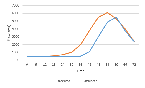
Figure 3Observational and calculated hurricane hydrograph in 1th March 2006.

Figure 4:  Calibration of SRM (1971-2005).

Rainfall Run-Off Model

In the present study, HEC-HMS model was used to convert rainfall into runoff. From the critical storms, several storms were selected to calibrate the model in terms of the quantity and quality of basic data. For example, in (Figure 3 & 4) observing and calculating hydrographs of the storm of March 1 in the year of 2006 hurricane, are shown in the Ghale-Shahrokh mapping hydrometric station for calibrating and validating the model. So, (Figure 3) shows that there is a delay between observed and modeled data. The comparison between hydrographs shows that there is a good fit between computational and observational hydrographs.

Snow Melting

In this study, a snow flake with a 100-year return period was used to estimate the contribution of snow melt to storm water and the maximum probable maximum flood. For this purpose, snow melting was used and the Meteorological Station of Ghale-Shahrokh was selected as the base meteorological station and the Ghale-Shahrokh hydrometric station as the base of the hydrometric station.

Hydrology years of 1971-2005 were selected for calibration and evaluation, respectively, due to more complete snow cover data. The determination coefficient for the calibration period is about 0.8, and the volume difference percentage for the aforementioned periods is 0.77, which indicates the proper performance of the model. (Figure 4) shows the observed and simulated snowmelt hydrographs for calibration period.

Table 1: Maximum probable precipitation depth at basin level.

Table 2: Comparison of the percentage of runoff variations caused by precipitation of the maximum future period with the current period under climate change.

Table 3: Comparison of the percentage changes in the runoff volume due to the maximum rainfall of the future period with the current period under the climate change.

Table 4: The flood variation ratio with a return period of 100 years due to snow melt in the course of the current period under the climate change conditions.

Table 5: Comparison of the maximum flood variations in the future period compared to the current period under different scenarios.

Results

As mentioned above, in this research, maximum probable precipitation is estimated by synoptic method. Due to temperature changes and its future period, the maximum probable precipitation for the future period is predicted for different continuations under scenarios RCP 2.6, RCP 4.5 and RCP 8.5. (Table 1) shows the maximum probable rainfall of the basin in the current and future periods under changing conditions and different scenarios. After calibrating the HEC-HMS model, using this model, the runoff was simulated with a maximum probable 24-hour, 48-hour and 72-hour rainfall. (Table 2) shows the comparison of rainfall runoff from the maximum 24hours, 48hours and 72hours for the current period and the upcoming period under changing conditions, as well as (Table 3) shows the comparing variations in runoff volume for the periods.

In the next stage, after calibration of the SRM snow melting model, snowmelt runoff using this model was simulated in the current and future period under the three climate scenarios, and the flood with a 100-year return period with Two-parameter gamma distribution and torque method were calculated (Table 4) shows Flood amounts due to snow melting with a return period of 100 years in the present and future periods under conditions of climate change.Finally, by adding the melting point to the runoff caused by maximum precipitation, the maximum probable flood of the basin was obtained in continues and different periods. (Table 5) shows the maximum variation of the probable river flood under scenarios different in comparison with the base course.

Discussion

Previous studies such as Xu [30] and Harris [31] and Beery [32] mentioned that still there is gap between selecting climate change model and modeling storm water. So, this study tried to fill the gap with using new method for selecting the model of climate change and analyze the effects of climate change on hydrological system of a catchment. Also, previous studies such as [33,34] did not analyze the effect of climate change on seasonal storm water. However, this study analyze the effects of climate change on hydrological seasons. In addition, previous studies such as [35-37] did not analyze the effect of snow melt in storm water simulation under the climate change effects. However, this study analyze the effect of snow melt in hydrology system of catchment and assess the effect of climate change on snow melt and storm water.

In this research, the effects of climate change on storm water and probability for maximum flood during the period 2006-2040 analyzed with using HadCM3, under the three scenarios climate change model showed that under the RCP 2.6 scenario, there is increase in temperature (0.35 ° C ) and under the RCP 4.5 scenario, there is increase in temperature (0.48 ° C ) and under the RCP 8.5  scenario, there is increase in temperature (0.53 ° C ). The warmer months of the year, warmer and cold months of the year, will experience changes that in general will change by 3% increase in the future temperature. Anomalies in temperature variations, even minor changes, will be the beginning of a change in the trend of many hydrological phenomena in the region. The trend of rainfall changes in the future will have a different behavior over the historical period. At the same time period, in some months of the year rainfall is decreasing and, in some months,, rainfall is increasing. According to rainfall forecast, under the scenario 1, maximum probable of precipitation is increased by 5% and under the scenario 2 the maximum probable of precipitation is decreased by 5% and under the scenario 3 the maximum probable of precipitation is decreased by 10% [38-40].

To simulate the rainfall - Runoff a hydrological model was used. According to rainfall-runoff forecast, under the scenario 1, maximum storm water is decreased by 1.23% and under the scenario 2 the maximum storm water is decreased by 1.25% and under the scenario 3 the maximum storm water is decreased by 1.53%. This increase over the course of the year is not the same and varies in different months. The existence of a difference in the predicted values of the climate change scenario for temperature and fluidity in different months during the evaluation period indicates that the uncertainty in the simulation under the phenomenon of climate change. Anyway in the appearance of such changes in temperature and precipitation, intensity and the duration of droughts will increase due to increased temperature and also the risk of flooding due to melting snow and increasing the evapotranspiration of plants from other disruptions to change the climate is in the region. Finally, it can be concluded that such studies and studies of future climate changes in the different regions or countries and simulation of rainfall-runoff and prediction of future runoff of rivers, can help to improve the possibility of making decisions management, modifying the probabilistic effects and applying new methods of adaptation to different climatic conditions and using the results of climatic research in areas where rainfall and runoff are increasing can help to predict the risk of flooding by hydrological models in those areas.

Conclusion

The result of this study showed that the variation in the studied basin would dramatically change precipitation, melting, and flooding. As shown in the results section, the maximum probable rainfall in the catchment area has occurred with different continents in December. During the period of 2006-2040 this month, under the scenario1, the precipitation can increase by 5 percentage, under the scenario 2, can decrease by 5%, and under the scenario 3 can decrease by 10%.

Accordingly, maximum flood variations for the upcoming period under the A1B, A2, and B1 scenarios for precipitation of 24 hours duration were 25.5, 24 and 9% respectively, and for precipitation with a duration of 48 hours, 19, 11 and 7.3%, and For precipitation with a duration of 72 hours, 18, 10 and 7.2 %, this change can affect the structures that are designed based on the maximum flood event or the structures that are being run along the river. Of course, it should be noted that due to the existence of different models of AOGCM, down scaling, different greenhouse gas emission scenarios, there is uncertainty in the final results of this research. It should also be noted that how simulation of runoff and snow melt modeling and calibration of models can affect the final results of maximum flood probability.

However, with the change in the severity of heavy rainfall and storms, it is recommended that water resource managers approach to water management practices that reduce the impact of severe storms and increase flexibility in water management. In addition, as suggestions for future studies, it is recommended to use evolutionary methods for optimization to calibrate the runoff rainfall model. Also, use of other models of runoff precipitation, other models - AOGCM and other scenarios for publication and comparison with the results of this study are recommended for future research.

Data Availability

Some or all data, models, or code used during the study were provided by a third party. Direct requests for these materials may be made to the provider as indicated in the Acknowledgements. The data include: Minimum temperature, maximum temperature, precipitation, sunny day, wind speed, dew point temperature, and pressure was obtained from the Esfahan Regional Water Authority, Meteorological Organization and the Ministry of Energy.

Acknowledgment and Funding

We thank Esfahan Regional Water Authority, Meteorological Organization and the Ministry of Energy for helping this study to collect necessary data easily without payment, Mohammad Abdollahi and Hamid Zakeri for their helpful contributions to collect the data. All other sources of funding for the research collected from authors. We thank Omid Boyer-hassani who provided professional services for check the grammar of this paper.

Competing Interests

“The authors declare that they have no competing interests.”

Authors Contributions

Safieh Javadinejad designed this research and she wrote this paper and she collected the necessary data and she did analysis of the data. Rebwar Dara participated in drafted the manuscript and he contributed in the collection of data and interpretation of data and edited the format of the paper under the manuscript style.

Forough Jafary participated in the data collected and data analysis.

More information regarding this Article visit: OAJBGSR